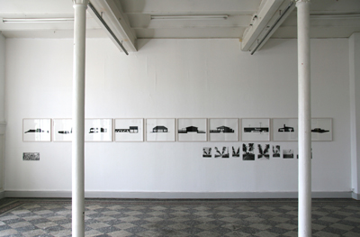
Installation view, Overdragelse Overgaden. Institut for Samtidskunst,
København, DK 29.8. - 26.10.2008
Centerline Rd or Queen Mary Highway is the road connecting the two townsFrederikssted and Christiansted on the Carribean island St. Croix in the US Virgin Islands. The work takes its departure point in this road and the historic meaning of it, and its names.
The Centerline was planned during danish colonial times (1752 - 1917), it was and still is the major traffic vein on the Island. It cuts through the tropical landscape in a straight line, planned in the rational spirit of enlightenment. The road is lined by architecture from all historic periods, each manifesting a certain moment in the history of St. Croix, from sugar mills and fortresses to contemporary urban sprawl.
For centuries the road was lined with royal palms, enhancing the perspective in the vista. The royal palms were vulnerable to hurricanes, and were replaced with mahogany trees in the 1930ies. From this moment the photographers seem to loose interest, and hardly any pictures are published of the Centerline Road in its modern version.
In 1973 the name was changed into Queen Mary Highway after the historical character Mary Thomas, who was one of the three female leaders, the „Queens“, front persons in a major workers revolt in 1878. The road is still referred to with both names, embodying the ambivalence of colonial history, memory and the moments of revolt and liberation.
The drawings are abstracted representations of road side architecture along Queen Mary Highway. The photocopies refer to the former vistas of the road, the central perspective with its male and western connotations. The battle scene is a contemporary representation of the Fireburn revolt in 1878, lead by black female workers.
10 gouache drawings (60 x 55 cm), 9 photocopies.